1/2


အေသးစိတ္မ်ားျပန္လည္သံုးသပ္မႈမ်ားဗားရွင္းမ်ားအချက်အလက်
1/2
၀ယ္ယူမႈတိုင္းတြင္ 20%အထိ ေဘာနပ္စ္။Digital Altimeter FREE တြင္ ေနာက္ထပ္ပစၥည္းမ်ားကို ရယူရန္ သင့္ AppCoins ေဘာနပ္စ္ကို အသံုးျပဳပါ။

၏ ရွင္းလင္းခ်က္ Digital Altimeter FREE
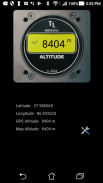
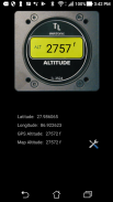
The digital altimeter uses the GPS and google map data server to display your altitude.
Features:
- Display the latitude and longitude
- Display the GPS altitude
- Display the Google map Altitude
- you can choose between the metric nad imperial unit system
အဆိုပါဒစ်ဂျစ်တယ် altimeter သင့်ရဲ့အမြင့်ကိုဖေါ်ပြဖို့ GPS နဲ့ google မြေပုံဒေတာဆာဗာကိုအသုံးပြုသည်။
အင်္ဂါရပ်များ:
- လတ္တီတွဒ်နှင့်လောင်ဂျီတွဒ်ပြသရန်
- ထို GPS စနစ်အမြင့်ပြသရန်
- ဂူဂဲလ်မြေပုံအမြင့်ပြသရန်
- သင်ကမက်ထရစ် nad ဧကရာဇ်ယူနစ်စနစ်ကအကြားရွေးချယ်နိုင်ပါသည်
Digital Altimeter FREE - ဗားရွင္း 1.1.8
(15-06-2020)ဘာအသစ္ရွိလဲA bug for the map elevation has been fixed.
ေကာင္းမြန္ေသာအက္ပ္ျဖစ္ေၾကာင္း အာမခံသည္ဤအက္ပ္သည္ ဗိုင္းရပ္စ္၊ ေမးလ္၀ဲႏွင့္ အျခားမသမာေသာ တိုက္ခိုက္မႈမ်ားအတြက္ လံုၿခံဳေရးစစ္ေဆးခ်က္ကို ေအာင္ျမင္ခဲ့ၿပီး မည္သည့္အႏၲရာယ္မွ် မရွိပါ။
Digital Altimeter FREE - APK သတင္းအခ်က္အလက္
APK ဗားရွင္း: 1.1.8package: com.giudicelli.digitalaltimeterအမည္: Digital Altimeter FREEအရြယ္အစား: 2.5 MBေဒါင္းလုဒ္မ်ား: 1.5Kဗားရွင္း : 1.1.8ျဖန္႔ခ်ိသည့္ ရက္စြဲ: 2020-06-15 03:14:09စခရင္အေသး: SMALLအေထာက္အပံ့ေပးနိုင္ေသာ စီပီယူ:
ပက္ေက့ဂ်္အိုင္ဒီ: com.giudicelli.digitalaltimeterSHA1 လက္မွတ္: B8:6A:A4:AA:18:CF:7B:3C:BE:69:B2:13:76:12:9E:01:99:78:E2:92ထုတ္လုပ္သူ (CN): အဖြဲ႕အစည္း (O): Patrick Giudicelliေဒသဆိုင္ရာ (L): နိုင္ငံ (C): ျပည္နယ္/ၿမိဳ႕ေတာ္ (ST):
က႑တူအက္ပ္မ်ား
သင္ႏွစ္သက္ႏိုင္သည္မ်ားမွာ...

English


